
Off the Beaten Track in Pu Luong: 7 Hidden Trails for 2026
Ready to go off the beaten track in Pu Luong? Find quiet villages, a cave trek and rice terrace routes most tour buses never reach.

To go off the beaten track in Pu Luong means skipping the main Pho Doan-Kho Muong loop that most day-tour buses run and instead trekking to villages like Don, Bang, and Kho Muong on foot, by bamboo raft, or on the back of a rented motorbike. Pu Luong Nature Reserve sits in northwestern Thanh Hoa province, roughly 180 km and a 3.5-4 hour drive from Hanoi, and it stays far quieter than Sapa or Mai Chau despite similar rice terrace scenery.
Travelers researching this keyword usually want to know which specific routes and villages avoid the crowds, since Pu Luong itself is already a secondary destination. The routes below trade paved viewpoints for streambed trails, cave systems, and homestays where the family still farms the rice you see from the porch.
A smaller group wants trekking logistics: how many days to allow, whether a guide is necessary, and when the rice terraces actually look their best. Both of those questions have concrete answers tied to the season and the specific trail you pick.
Below, this guide walks through what counts as truly off-route in Pu Luong, the villages worth the extra walking, how to get there from Hanoi, and what to check before you fly into Vietnam in the first place.
Pu Luong quiet-trail trekking in brief:
| Item | Detail |
|---|---|
| Distance from Hanoi | Approximately 180 km, 3.5-4 hours by road |
| Quietest villages | Kho Muong, Don, Bang, Nua |
| Standout trek | Kho Muong to Hieu Waterfall, 7-8 hours |
| Highest point | Pu Luong peak, 1,700 meters |
| Best trekking months | October to December and March to May |
| Where to sleep | Homestays and eco-lodges run by Thai and Muong families |
| Local transport | Motorbike rental, private driver, or on foot with a guide |
| Guide recommended | Yes, for the Kho Muong cave and Dong Dieng routes |
What Counts as Off the Beaten Track in Pu Luong?
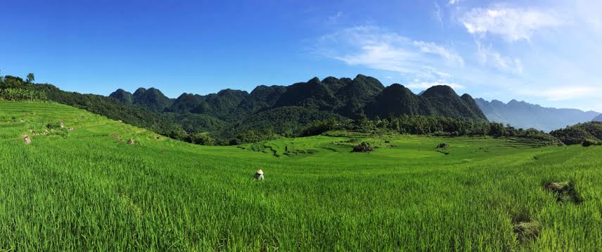
These footpaths connect Kho Muong, Don, Bang, and Nua villages, running past the sealed road that most rental cars and day-trip vans use to reach the main viewpoints. The reserve already sees far fewer visitors than Sapa, but even inside Pu Luong there is a well-worn tourist circuit and a much quieter network of trails.
The paved circuit runs past the famous water wheels near Ban Nua and a handful of photogenic overlooks. However, it also means sharing the view with several other minivans by mid-morning.
The alternative routes drop off that road entirely. You walk through working rice paddies, cross streams on bamboo footbridges, and pass through hamlets with no signage aimed at tourists at all.
Which Villages and Trails Escape the Crowds?
Four villages anchor the quieter side of Pu Luong: Kho Muong, Don, Bang, and Nua, each reached by a different combination of trekking and short drives. Below are the two routes locals and specialist trekking guides point to most often.
Kho Muong Village and Cave Trek
Kho Muong sits in an isolated valley reached by a steep trail down from Dong Dieng village, through several kilometers of terraced rice fields. The walk down takes you past working farms rather than photo stops built for tour groups.
Kho Muong Cave, the largest cave in the reserve, opens near the village and is worth the detour before you continue on. From there, the trail climbs roughly 700 meters back up toward Bang village, crossing streams and forest paths that see a fraction of the foot traffic on the main road.
- Starting point: Dong Dieng village, reached by car or motorbike from the main road.
- Midpoint: Kho Muong village and its cave, in a valley surrounded by karst hills.
- Endpoint: Bang village, connecting back to homestay accommodation.
- Difficulty: Moderate, with one steep climb section.
Kho Muong to Hieu Waterfall
For a longer day, the Kho Muong to Hieu Waterfall trek covers 7-8 hours through forest, rice terraces, and small Thai and Muong hamlets before reaching the waterfall itself. Guides rate it moderately challenging rather than technical, since the terrain is mostly uphill and downhill footpath rather than rock scrambling.
Experienced hikers can extend the day further toward Pu Luong's highest peak at 1,700 meters, usually with an overnight camp near the summit and an experienced local guide. That extension is a separate, full-day commitment on top of the standard route, not something to add on casually.
How Do You Reach Pu Luong from Hanoi?
You reach Pu Luong from Hanoi by road, since there is no rail or air link into Thanh Hoa's northwestern district where the reserve sits. Most independent travelers choose one of three methods.
- Rent a self-drive motorbike in Hanoi and ride Route 6 toward Mai Chau, then continue into Pu Luong, a trip of roughly 4 hours for a confident rider.
- Book a private car or driver, which takes about the same time but skips the traffic risk on Vietnam's mountain roads.
- Join a scheduled trekking tour that includes hotel pickup, transport, and a local guide for the off-route sections.
Note: the road into Pu Luong narrows considerably past Mai Chau, and the final stretch to villages like Kho Muong is trail only, not passable by car. Plan for a mix of driving and walking regardless of which option you pick.
When Is the Best Time to Trek Pu Luong's Quiet Trails?
The best months are October to December, when the rice has just been harvested and the terraces turn gold, or March to May, when the fields are freshly flooded and planted. Both windows also bring cooler, drier trekking weather than the summer months.
| Season | Conditions | Rice terrace look |
|---|---|---|
| March-May | Warm, drier trails | Freshly flooded, green shoots |
| June-August | Hot, frequent rain | Deep green, muddy trails |
| September-October | Cooling, occasional storms | Golden, ready for harvest |
| November-December | Cool, dry | Harvested, terraced fields visible |
Summer brings the heaviest rain and the highest risk of slippery, difficult trail conditions on the steeper Kho Muong descent. If your trip falls in June through August, build in extra time and expect muddier river crossings.
What Else Should You Know Before Trekking Pu Luong?
Beyond picking a route and a season, a short packing list and a decision on guided versus independent trekking will shape how smooth the trip feels once you are on the trail.
What to Pack for the Trail
- Sturdy, broken-in walking shoes with grip, not sandals.
- A rain layer, even outside the wet season, since mountain weather shifts fast.
- Cash in Vietnamese dong for homestays and small village shops that do not take cards.
- A basic first-aid kit and insect repellent for the forest sections.
- A headlamp if your itinerary includes the Kho Muong cave detour.
Guided vs Independent Trekking
Guided treks make sense for the Kho Muong cave route and the Dong Dieng descent, both of which involve unmarked trail junctions and one steep section. Independent trekking suits the paved water-wheel loop near Ban Nua, where the path is obvious. If your goal is genuinely to reach Pu Luong's quieter side, budget for a guide on at least one day.
Before You Travel: Vietnam Visa Requirements
Most foreign travelers heading to Pu Luong enter Vietnam through Hanoi's Noi Bai International Airport, so a Vietnam e-visa or visa on arrival needs to be arranged before departure, not at the border. The e-visa works for air, land, and sea entry, while visa on arrival applies to air travel only and still requires an approval letter in hand before boarding.
Check your passport validity and nationality against the current visa-exemption list before booking flights, since standard processing takes a few working days. Review current e-visa and visa on arrival fees before you apply, then apply through vietnamvisa-easy.com, a private visa service agency, not a government office.
If you are mapping out a wider northern Vietnam itinerary, see our related guide to applying for your Vietnam visa for how Pu Luong fits alongside other regions.
- No Hidden Charges
- Competitive price
- Fast reliable services
- Prompt Support via chat, email, phone
- Customer - Focused approach
- Money-back guarantee for declined applications
Frequently Asked Questions
How many days do you need to trek Pu Luong's quiet trails?
Plan at least 2 full days: one for the Kho Muong cave and Bang village route, one for the Hieu Waterfall trek or a rest day at a homestay.
Do you need a guide for the Kho Muong trail?
Yes. The trail junctions are unmarked, and one section involves a steep climb.
Can you visit Pu Luong as a day trip from Hanoi?
A day trip covers only the paved water-wheel loop. Seeing Kho Muong or Bang properly requires an overnight stay.
What is the biggest cave in Pu Luong Nature Reserve?
Kho Muong Cave, near the village of the same name, sits along the Dong Dieng to Bang trekking route.
Is Pu Luong less crowded than Sapa?
Yes, and the off-route trails to Kho Muong, Don, and Bang see fewer visitors still, even in peak season.
